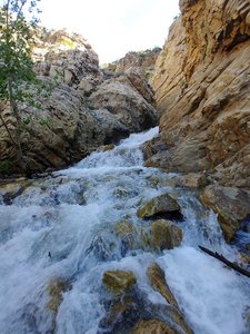
36th Street Trailhead Waterfall in Ogden, Utah
The 36th Street Trailhead in Ogden, Utah offers a delightful hiking experience with its connection to Strongs Canyon and the Bonneville Shoreline Trail. The trail is well-shaded, providing a cool and pleasant hike, though parts of it are often covered in water. Hikers can enjoy ample parking and a variety of paths, including links to Gib's Loop and Waterfall and Strong canyons. While the trail is lively with wildlife, visitors should be cautious of rattlesnakes, especially during the summer months.
Map
Address
36th St
Ogden, Utah 84403
Features
- Parking_Available
- Family_Friendly
- Quiet_Peaceful
- Scenic_Views
- Wildlife_Sightings
- Waterfall_Flowing
- Well_Marked_Trail
- Shaded_Trail
- Picnic_Area
Seasonal Guide
| Season | Best Time To See | Avg. Temp (°F) |
|---|---|---|
| ☀️ Summer | Maybe - Dense foliage partially obscures view | 75-90 |
| 🌸 Spring | Yes - Lush greenery and good weather | 50-70 |
| 🍂 Fall | Maybe - Foliage may obscure view, but pleasant weather | 45-65 |
| ❄️ Winter | Yes - Clear view, cooler weather | 30-50 |
Tips for Visitors
Preparation
As amenities may be minimal near the site, it's wise to pack essentials like water, snacks, and weather-appropriate clothing. Check local weather and trail conditions before setting out.
Navigation
Utilizing a GPS or a detailed local map is recommended, as signage in more remote areas can be limited. Apps like Google Maps or specialized hiking trail apps can be useful to ensure you're on the right path.
Respecting Nature
As with any natural site, practice Leave No Trace principles. This helps preserve the pristine condition of 36th Street Trailhead for future visitors and protects the local ecosystem.
More Waterfalls in Utah