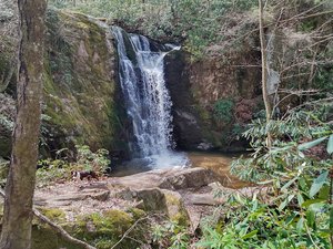
Laurel Falls Waterfall in Crawford, Tennessee
Laurel Falls, located in Tennessee, offers a stunning waterfall experience accompanied by a scenic hike through the Laurel-Snow State Natural Area. The hike is approximately five miles long and begins with a gentle walk along Richland Creek, where remnants of the area's coal mining history can be seen. As the trail progresses, hikers encounter a challenging series of rocky switchbacks leading up to the majestic 93-foot Laurel Falls. Visitors should be mindful of navigation, as GPS directions may lead to private roads; using the natural area's website for guidance is recommended.
Map
Address
Crawford, Tennessee 37321
Features
- Family_Friendly
- Quiet_Peaceful
- Scenic_Views
- Waterfall_Flowing
- Shaded_Trail
- Rocky_Terrain
- Steep_Climb
Seasonal Guide
| Season | Best Time To See | Avg. Temp (°F) |
|---|---|---|
| ☀️ Summer | Maybe - Dense foliage partially obscures view | 75-90 |
| 🌸 Spring | Yes - Lush greenery and good weather | 50-70 |
| 🍂 Fall | Maybe - Foliage may obscure view, but pleasant weather | 45-65 |
| ❄️ Winter | Yes - Clear view, cooler weather | 30-50 |
Tips for Visitors
Preparation
As amenities may be minimal near the site, it's wise to pack essentials like water, snacks, and weather-appropriate clothing. Check local weather and trail conditions before setting out.
Navigation
Utilizing a GPS or a detailed local map is recommended, as signage in more remote areas can be limited. Apps like Google Maps or specialized hiking trail apps can be useful to ensure you're on the right path.
Respecting Nature
As with any natural site, practice Leave No Trace principles. This helps preserve the pristine condition of Laurel Falls for future visitors and protects the local ecosystem.
More Waterfalls in Tennessee