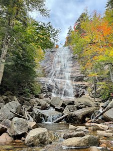
Arethusa Falls Waterfall in Livermore, New Hampshire
Arethusa Falls in Livermore, New Hampshire, is a breathtaking sight that is believed to be the tallest single-drop waterfall in the state. The hike to reach this natural wonder is approximately 1.4 miles with a steady 900-foot elevation gain, making it an easy-to-moderate trek for experienced hikers, but potentially challenging for beginners due to the rocky and root-laden path. The trail is well-marked, and the surrounding area offers additional exploration opportunities, such as Bemis and Coliseum Falls, though these routes can be more difficult and involve steep rock scrambles. Overall, Arethusa Falls provides a rewarding experience for those willing to tackle the terrain, with ample parking available for a small fee.
Map
Address
Livermore, New Hampshire 3812
Features
- Parking_Available
- Scenic_Views
- Waterfall_Flowing
- Well_Marked_Trail
- Rocky_Terrain
- Steep_Climb
Seasonal Guide
| Season | Best Time To See | Avg. Temp (°F) |
|---|---|---|
| ☀️ Summer | Maybe - Dense foliage partially obscures view | 75-90 |
| 🌸 Spring | Yes - Lush greenery and good weather | 50-70 |
| 🍂 Fall | Maybe - Foliage may obscure view, but pleasant weather | 45-65 |
| ❄️ Winter | Yes - Clear view, cooler weather | 30-50 |
Tips for Visitors
Preparation
As amenities may be minimal near the site, it's wise to pack essentials like water, snacks, and weather-appropriate clothing. Check local weather and trail conditions before setting out.
Navigation
Utilizing a GPS or a detailed local map is recommended, as signage in more remote areas can be limited. Apps like Google Maps or specialized hiking trail apps can be useful to ensure you're on the right path.
Respecting Nature
As with any natural site, practice Leave No Trace principles. This helps preserve the pristine condition of Arethusa Falls for future visitors and protects the local ecosystem.
More Waterfalls in New Hampshire