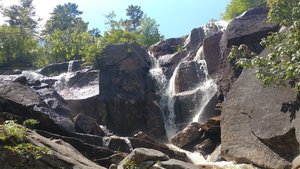
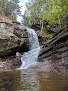
Bridalveil Falls Waterfall in Franconia, New Hampshire
Bridalveil Falls in Franconia, New Hampshire, offers visitors a picturesque hiking experience. The trail is moderate, taking about an hour uphill on the Coppermine Trail and is well-marked with yellow markers, ensuring hikers can find their way with ease. Despite some slippery rocks near the top, the falls provide a comfortable spot for lunch with both sun and shade options, and shallow water spots for swimming are found along the way. While parking can be limited, the area was pleasantly uncrowded, making it a worthwhile destination for a peaceful outing.
Map
Address
Franconia, New Hampshire 3580
Features
- Family_Friendly
- Scenic_Views
- Waterfall_Flowing
- Well_Marked_Trail
- Shaded_Trail
- Rocky_Terrain
- Steep_Climb
- Picnic_Area
Seasonal Guide
| Season | Best Time To See | Avg. Temp (°F) |
|---|---|---|
| ☀️ Summer | Maybe - Dense foliage partially obscures view | 75-90 |
| 🌸 Spring | Yes - Lush greenery and good weather | 50-70 |
| 🍂 Fall | Maybe - Foliage may obscure view, but pleasant weather | 45-65 |
| ❄️ Winter | Yes - Clear view, cooler weather | 30-50 |
Tips for Visitors
Preparation
As amenities may be minimal near the site, it's wise to pack essentials like water, snacks, and weather-appropriate clothing. Check local weather and trail conditions before setting out.
Navigation
Utilizing a GPS or a detailed local map is recommended, as signage in more remote areas can be limited. Apps like Google Maps or specialized hiking trail apps can be useful to ensure you're on the right path.
Respecting Nature
As with any natural site, practice Leave No Trace principles. This helps preserve the pristine condition of Bridalveil Falls for future visitors and protects the local ecosystem.
More Waterfalls in New Hampshire