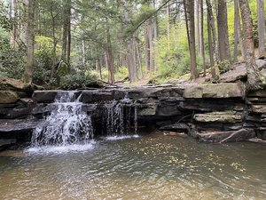
Gilpin’s Falls Covered Bridge Waterfall in North East, Maryland
Gilpin's Falls Covered Bridge in North East, Maryland, offers a charming combination of natural beauty and historical intrigue. The creek flows over the dam, creating a scenic backdrop, though visitors should prepare for a quick hike with limited amenities, such as no bathrooms and small parking spaces. While the trail down to the falls can be rough and slippery, the experience of crossing the covered bridge to reach the main attraction is worthwhile. With its impressive rock formations and picturesque views, Gilpin's Falls is a beautiful spot for a hike, but safety precautions are advised due to boulders and uneven terrain.
Map
Address
North East Rd
North East, Maryland 21901
Features
- Scenic_Views
- Waterfall_Flowing
- Well_Marked_Trail
- Rocky_Terrain
Seasonal Guide
| Season | Best Time To See | Avg. Temp (°F) |
|---|---|---|
| ☀️ Summer | Maybe - Dense foliage partially obscures view | 75-90 |
| 🌸 Spring | Yes - Lush greenery and good weather | 50-70 |
| 🍂 Fall | Maybe - Foliage may obscure view, but pleasant weather | 45-65 |
| ❄️ Winter | Yes - Clear view, cooler weather | 30-50 |
Tips for Visitors
Preparation
As amenities may be minimal near the site, it's wise to pack essentials like water, snacks, and weather-appropriate clothing. Check local weather and trail conditions before setting out.
Navigation
Utilizing a GPS or a detailed local map is recommended, as signage in more remote areas can be limited. Apps like Google Maps or specialized hiking trail apps can be useful to ensure you're on the right path.
Respecting Nature
As with any natural site, practice Leave No Trace principles. This helps preserve the pristine condition of Gilpin’s Falls Covered Bridge for future visitors and protects the local ecosystem.
More Waterfalls in Maryland