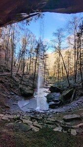
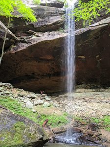
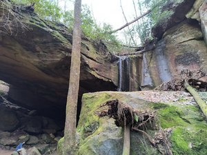
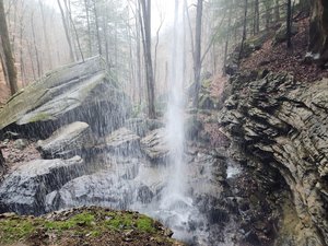
Anglin Falls Waterfall in Chaplin, Kentucky
Anglin Falls in Kentucky offers a delightful hiking experience with a trail that's roughly 0.7 miles in each direction. The path is mostly easy to manage, though the last stretch features steep rocks that require a bit of scrambling, especially in wet conditions. Despite these challenges, the waterfall itself is stunning, particularly after rainfall, which enhances the beauty of the falls and surrounding area. Visitors should note that proper trail directions are crucial as incorrect ones may lead to private property.
Map
Address
Chaplin, Kentucky 40456
Features
- Scenic_Views
- Rocky_Terrain
- Steep_Climb
Seasonal Guide
| Season | Best Time To See | Avg. Temp (°F) |
|---|---|---|
| ☀️ Summer | Maybe - Dense foliage partially obscures view | 75-90 |
| 🌸 Spring | Yes - Lush greenery and good weather | 50-70 |
| 🍂 Fall | Maybe - Foliage may obscure view, but pleasant weather | 45-65 |
| ❄️ Winter | Yes - Clear view, cooler weather | 30-50 |
Tips for Visitors
Preparation
As amenities may be minimal near the site, it's wise to pack essentials like water, snacks, and weather-appropriate clothing. Check local weather and trail conditions before setting out.
Navigation
Utilizing a GPS or a detailed local map is recommended, as signage in more remote areas can be limited. Apps like Google Maps or specialized hiking trail apps can be useful to ensure you're on the right path.
Respecting Nature
As with any natural site, practice Leave No Trace principles. This helps preserve the pristine condition of Anglin Falls for future visitors and protects the local ecosystem.
More Waterfalls in Kentucky