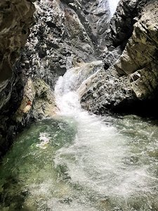
Apache Falls Waterfall in Colorado Springs, Colorado
Apache Falls, located in the stunning Greenhorn Mountain Wilderness of Colorado, offers an exhilarating and challenging hiking experience for those up to the task. Starting from the trailhead at the end of Bartlett Trail in Rye, the 11-mile round trip hike features a steep uphill climb followed by a descent on South Apache Trail, with some sections covered in deep snow. Despite the rigorous trek, hikers are rewarded with breathtaking views along the trail and the majestic sight of Apache Falls, enhanced by a striking ice formation at its base during colder months. The return journey, though demanding, promises a satisfying and picturesque adventure for nature enthusiasts.
Map
Address
Colorado Springs, Colorado 81069
Features
- Parking_Available
- Scenic_Views
- Waterfall_Flowing
- Steep_Climb
Seasonal Guide
| Season | Best Time To See | Avg. Temp (°F) |
|---|---|---|
| ☀️ Summer | Maybe - Dense foliage partially obscures view | 75-90 |
| 🌸 Spring | Yes - Lush greenery and good weather | 50-70 |
| 🍂 Fall | Maybe - Foliage may obscure view, but pleasant weather | 45-65 |
| ❄️ Winter | Yes - Clear view, cooler weather | 30-50 |
Tips for Visitors
Preparation
As amenities may be minimal near the site, it's wise to pack essentials like water, snacks, and weather-appropriate clothing. Check local weather and trail conditions before setting out.
Navigation
Utilizing a GPS or a detailed local map is recommended, as signage in more remote areas can be limited. Apps like Google Maps or specialized hiking trail apps can be useful to ensure you're on the right path.
Respecting Nature
As with any natural site, practice Leave No Trace principles. This helps preserve the pristine condition of Apache Falls for future visitors and protects the local ecosystem.
More Waterfalls in Colorado