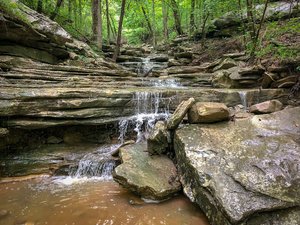
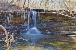
Laurel Falls Trailhead Waterfall in Fort Payne, Alabama
Laurel Falls Trailhead in Fort Payne, Alabama, offers a pleasant hiking experience with well-marked trails that make navigation easy. Although visitors may not always see falls or running water, the trail is rich with plants, flowers, and interesting rock formations that make the journey worthwhile. While the trail is popular, it remains relatively uncrowded, providing a peaceful adventure for nature lovers. However, hikers should be cautious of a few slick spots in late fall and occasional trail markings that could use some updates.
Map
Address
6914 Womack Dr NE
Fort Payne, Alabama 35967
Features
- Crowded
- Scenic_Views
- Well_Marked_Trail
- Rocky_Terrain
Seasonal Guide
| Season | Best Time To See | Avg. Temp (°F) |
|---|---|---|
| ☀️ Summer | Maybe - Dense foliage partially obscures view | 75-90 |
| 🌸 Spring | Yes - Lush greenery and good weather | 50-70 |
| 🍂 Fall | Maybe - Foliage may obscure view, but pleasant weather | 45-65 |
| ❄️ Winter | Yes - Clear view, cooler weather | 30-50 |
Tips for Visitors
Preparation
As amenities may be minimal near the site, it's wise to pack essentials like water, snacks, and weather-appropriate clothing. Check local weather and trail conditions before setting out.
Navigation
Utilizing a GPS or a detailed local map is recommended, as signage in more remote areas can be limited. Apps like Google Maps or specialized hiking trail apps can be useful to ensure you're on the right path.
Respecting Nature
As with any natural site, practice Leave No Trace principles. This helps preserve the pristine condition of Laurel Falls Trailhead for future visitors and protects the local ecosystem.
More Waterfalls in Alabama